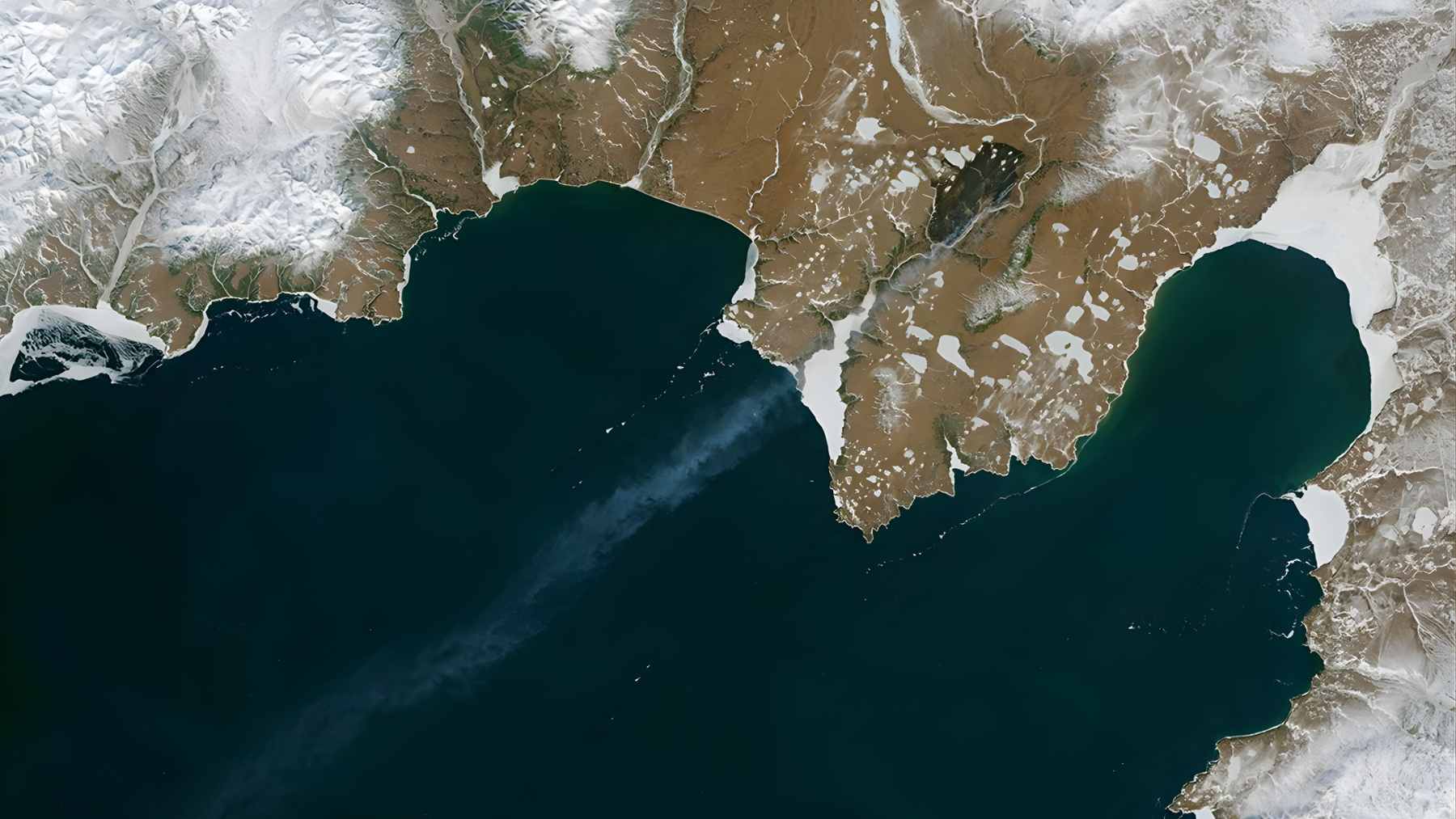
New images from NASA Earth Observatory show something that once seemed almost impossible near the top of the world. Bright wildfire plumes now snake across patches of snow and frozen lakes in the high Arctic, creating what researchers are calling “fire on ice.”
These scenes are becoming more common, not less, as the region heats up much faster than the rest of the planet.
According to NASA scientists and a 2025 assessment from the Arctic Monitoring and Assessment Programme for the Arctic Council, wildland fires in the Arctic are now more frequent, larger, and longer lasting than they were just a few decades ago.
The same research links this shift to a landscape that is drying out as the Arctic warms nearly four times faster than the global average.
Fires in a place we expect to stay frozen
Most of us picture the Arctic as a solid white cap on the weather map. In reality it is a patchwork of dark green boreal forests, low shrubs, grassland tundra, and finally bare rock and ice near the pole.
When winter snow melts, that exposed vegetation can dry quickly in the long polar daylight. Give it a spark from a lightning strike and it can burn, even with sea ice still lingering just offshore.
Recent satellite records from instruments such as MODIS on the Terra and Aqua missions show that fire detections have crept steadily north. Maps comparing 2002 to 2012 with 2012 to 2025 contain far more fire pixels and many of them sit at higher latitudes than before.
A new era of extreme Arctic fires
For scientists at NASA Ames Research Center, the worrying part is not only the number of fires but how they behave. Jessica McCarty, who led the fire chapter in the AMAP report, notes that “fire has always been part of boreal and Arctic landscapes, but now it is acting in much more extreme ways.”
In the past, many northern fires burned at low intensity. They scorched the surface but left most trees standing and allowed soils to recover.
Now researchers are documenting more events that kill entire stands, strip away the organic top layer, and even ignite deep underground. Tatiana Loboda from the University of Maryland explains that “it is the intensity that worries us the most because it has the strongest effect on how ecosystems are changing.”
Looking back over several decades, Brendan Rogers of the Woodwell Climate Research Center estimates that the average burned area in the North American Arctic is now about twice what it was in the mid twentieth century.
That means more forest and tundra turning to ash, more smoke in the air, and more stored carbon heading upward into the atmosphere.
 1")
Peat, permafrost and ancient carbon on the line
Beneath the moss and stunted trees lies the Arctic’s hidden fuel. Much of the region sits on peat, a carbon rich soil made of partially decomposed plants that has been accumulating since the last ice age.
Below that, in many places, lies permafrost, ground that has stayed frozen for tens of thousands of years and still holds ancient roots, leaves, and even blades of grass in suspended animation.
When fires burn hot enough to reach that deep peat, they can create “zombie fires.” These holdover fires smolder underground through winter, then flare back to life when spring dries the surface.
At the same time, thawing permafrost can cause the land to sag into ponds or tilt trees into so called “drunken forests,” reshaping entire hillsides and valleys.
Together, Arctic peat and permafrost store roughly twice as much carbon as Earth’s atmosphere. When that ancient material thaws or burns, microbes and flames turn it into carbon dioxide and methane, adding to the greenhouse gases already driving global warming.
At the end of the day, every flare up of fire on ice nudges the climate system a little further away from the conditions humans have known for millennia.
From Arctic smoke to everyday life
All of this might sound distant if you live thousands of miles from the Arctic Circle. Yet smoke from northern fires does not respect borders. Studies show that plumes from high latitude wildfires can travel across continents, degrading air quality in countries far from the original flames and raising fine particle levels that irritate lungs and hearts.
Many people have already seen strange orange sunsets or hazy skies in recent summers that trace back to fires in boreal and Arctic regions.
More carbon in the atmosphere, in turn, raises the odds of heat waves, heavy downpours, and other extremes that show up in daily life, from higher air conditioning bills in summer to flooded basements after intense storms.
The Arctic may feel far away, but its new fire regime is tightly tied to the weather and climate we experience at home.
Satellites as an early warning system
One thing gives scientists some optimism. Long term satellite records now provide a detailed view of where and how Arctic fires are changing. NASA’s fleet has built up more than twenty five years of wildfire data, and new missions plus artificial intelligence tools are helping researchers track ignition sources, fuel conditions, and fire behavior in near real time.
Experts argue that more targeted observations and better models can support northern communities, land managers, and policymakers as they prepare for a hotter, more flammable Arctic.
The same data can also help the rest of the world understand how much additional carbon these fires may release and how that will ripple through the climate system.
The official article was published on NASA Science.