For more than a thousand years, the palatial city of Madinat al Zāhira existed mostly in chronicles and legend. Now a high-tech scan of the hills east of Córdoba suggests the lost residence of the powerful ruler Almanzor may finally have a real address on the map.
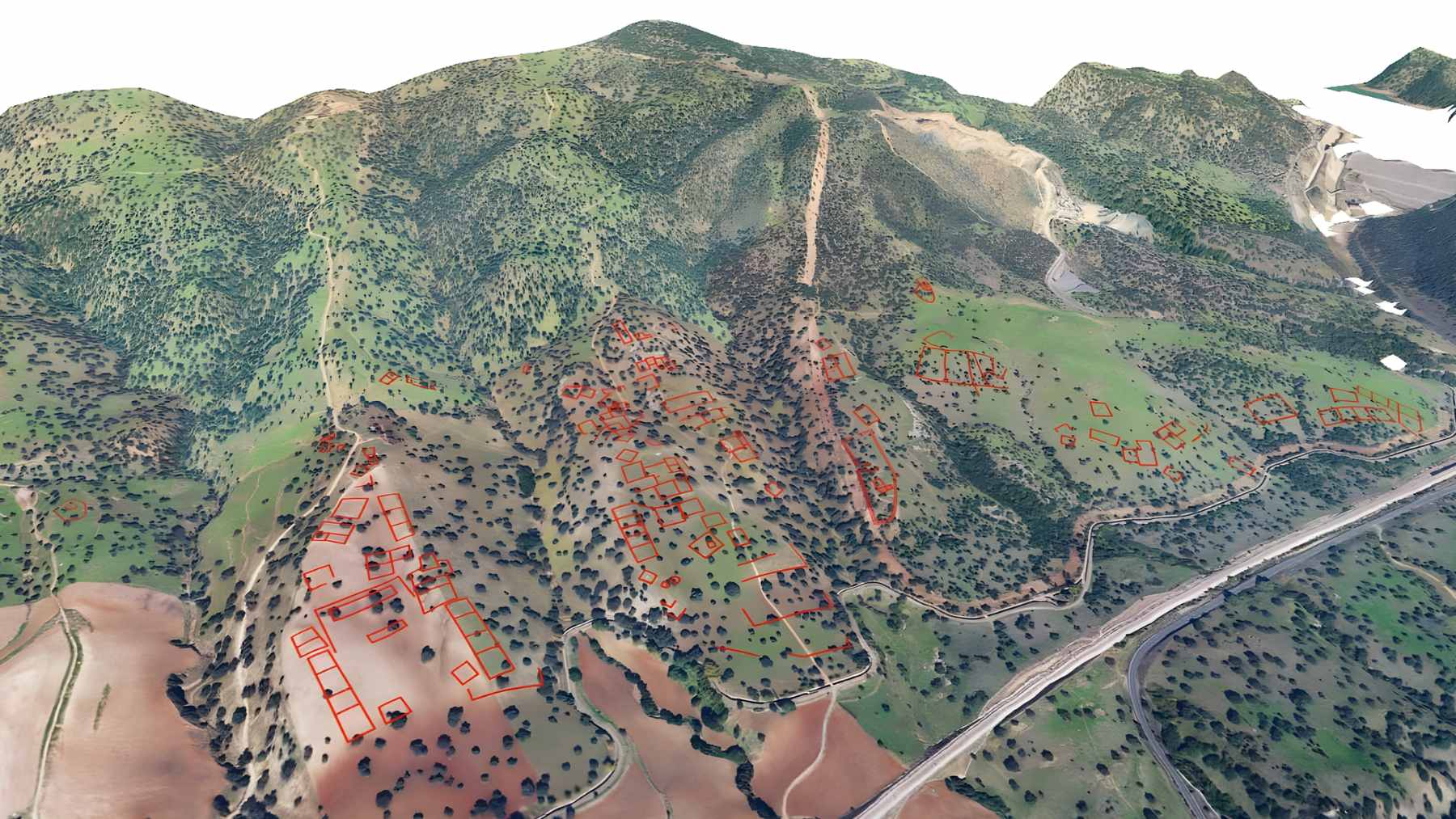
Using airborne LiDAR data from Spain’s national mapping program, archaeologist Antonio Monterroso Checa of the University of Córdoba has identified a buried urban layout covering about 120 hectares near the village of Alcolea, roughly 12 kilometers from Córdoba’s Mosque Cathedral.
The pattern of terraces, streets and buildings matches what historians expect from the vanished 10th-century city, turning a long-running historical mystery into a testable archaeological hypothesis.
A lost city comes into focus
Madinat al Zāhira was built in the late 10th century as the glittering power center of Almanzor, the effective ruler of Al Andalus. It was said to rival Madinat al Zahra on Córdoba’s western side, yet within a few decades of Almanzor’s death it was attacked and erased from the landscape.
Historians have argued over its location ever since, placing it in at least twenty two different spots in and around Córdoba, usually with little more than textual hints to go on.
Monterroso’s new study takes a different path. Instead of starting from medieval descriptions and working outward, he begins with the land itself.
By processing millions of LiDAR points collected by aircraft and released by Spain’s Instituto Geográfico Nacional, he generated extremely detailed digital elevation models of the countryside around the La Pendolilla estate near Alcolea.
Once vegetation and modern features are filtered away, the hills reveal a strikingly ordered relief. Rectangular and square platforms line up along artificial terraces.
Some structures keep a regular north south grid. Others twist to face the southeast, a direction that matches the orientation toward Mecca typical of Andalusi mosques. The built area stretches over roughly 120 hectares, almost the same footprint as Madinat al Zahra on the other side of the city.
For an urban complex that allegedly housed a court, military barracks, workshops and gardens, that kind of scale matters.
How LiDAR lets archaeologists “peel back” the ground
LiDAR, short for Light Detection and Ranging, sends rapid pulses of laser light from a plane or drone and measures how long they take to bounce back. With enough pulses, researchers can build three-dimensional maps accurate to a few centimeters, even under tree cover or scrub that hide subtle bumps from the naked eye.
In archaeology, those maps often act like a digital X-ray of the landscape. They can expose buried roads, long leveled walls, forgotten canals and even entire city plans that survive only as gentle rises and depressions.
From Mayan lowlands in Guatemala to fortifications in the Amazon, LiDAR has already redrawn the scale of ancient urbanism in many parts of the world.

In Córdoba’s case, the data were not collected for archaeology at all. They come from a nationwide LiDAR survey used for everything from flood modeling to forestry. Monterroso’s team repurposed the latest, higher-resolution coverage and ran it through custom visualizations that exaggerate micro relief.
The result is a kind of digital rubbing of the hills east of the city, where the suspected palace city now emerges as a faint yet coherent grid.
It is still all pixels and probabilities. Not a single trench has been dug at the site for this project.
What happens next on the ground
If further work confirms that the terraces and platforms near Alcolea belong to Madinat al Zāhira, Spain will suddenly be dealing with one of the largest unexcavated Islamic period cities in Europe.
The area has long functioned as pasture and royal estate land, including historic horse breeding grounds, which may have helped preserve the subsoil remains.
That raises practical questions. How much of the site should be excavated, and how quickly? Who pays to protect a buried city that you cannot yet visit on a weekend trip? Local debates are already touching on cultural policy and budgets, since any large-scale dig would compete with ongoing work at Madinat al Zahra and other Andalusi monuments.
For now, the discovery mainly shows how 21st-century tools are reshaping what we know about the Middle Ages. A thousand-year-old palace complex, flattened and forgotten, may have survived as nothing more than a pattern in the ground that only a laser can clearly see.
If shovels eventually confirm what the pixels are telling archaeologists, Madinat al Zāhira will move from legend to GPS coordinates, and Córdoba will gain a second monumental city from the age of the caliphs.
The study was published in Meridies. Estudios de Historia y Patrimonio de la Edad Media.